
Why The Middle East Is In The West Blame The 1525 Error
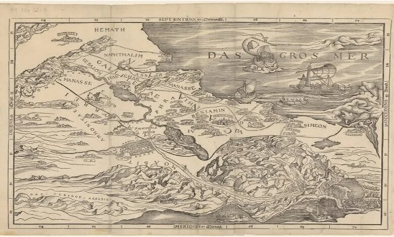
The first Bible with a map of the Holy Land appeared in 1525, exactly 500 years ago. The map’s author, Lucas Cranach the Elder, and publisher Christopher Froschauer in Zurich made an unusual mistake: the map was printed upside down. The Mediterranean Sea was in the east, and Palestine was in the west.Despite this, the publication had a huge impact on the understanding of the territory, boundaries and geography of the Bible.
“This is both one of publishing’s greatest failures and triumphs. The Europeans knew very little about this region, and no one in the workshop noticed the inverted position of the sea. But this map forever changed the understanding of the Bible, and today most editions contain maps,” says Nathan Macdonald, professor of Old Testament exegesis at Cambridge.
How Cranach’s map changed the way we look at the Bible
According to MacDonald’s study published in Journal of Theological Studies,The map not only visualized biblical events, but also shaped early ideas about territorial organization. For the first time, readers could “see” the division of the Promised Land into twelve tribes and the travel routes from the Book of Exodus and the Book of Joshua. Although the map was based on a medieval tradition – narrow, long strips of land, simplified based on the writings of Josephus – it helped to understand complex and contradictory biblical descriptions.
“There is no consistent picture of land distribution in Joshua 13–19. Cranach’s map provided the reader with a visual outline, even if it was geographically inaccurate,” MacDonald explains.
The Bible (Book of Joshua) tells how, after leaving Egypt and conquering the Promised Land (Palestine), it was divided between12 tribes– descendants of the 12 sons of Jacob (Israel). Each tribe received its own piece of land.
The Map and the Swiss Reformation
The appearance of the map coincided with a growing interest in the literal interpretation of Scripture during the Reformation era. Zurich became a center of publication where such maps were accepted as a legitimate visual aid.
It was these lines that becamethe first mass example“maps with boundaries” in bookswhich were read by millions of Europeans. People are accustomed to seeing the earth as a set of “their” territories with clear edges. Then this template migrated to world maps –and we still live with the idea that every country should have smooth, inviolable borders.
“People would look at a map and think of Mount Carmel or Nazareth or the Jordan River and would make pilgrimages without leaving their homes,” MacDonald says.
Maps helped to understand that biblical events took place in specific places, making sacred history tangible and accessible. They replaced forbidden images and became part of religious practice.
The Evolution of the Bible and Borders
The addition of Cranach’s map was an important milestone in the history of the Bible. It accompanied other changes: the transition from scrolls to bound books, the creation of portable single-volume Bibles, the introduction of chapter and verse divisions, the prefaces of the Reformation, and the recognition of prophetic poetry.
“The Bible was never a static book; it was constantly changing,” reminds MacDonald
Interestingly, the lines denoting the territories of the twelve tribes became the prototype of modern political boundaries.
“Biblical maps describing the division of the Promised Land shaped ideas about political boundaries, even if the text did not suggest them in the modern sense,” MacDonald explains.
Lines on maps began to symbolize the limits of sovereignty rather than the limitless promises of God.
Why is this important today
Macdonald emphasizes that for many people the Bible remains the source of ideas about nation and borders.
“When modern people see the Bible as a confirmation of political boundaries, they often simplify the ancient texts and interpret them literally. But people should be careful with such statements,” the professor says.
Thus, Cranach’s error of 1525 not only upended the map of the Holy Land, but also had a lasting impact on the perception of geography, political boundaries, and biblical history for centuries.
Disclaimer: This news article has been republished exactly as it appeared on its original source, without any modification.
We do not take any responsibility for its content, which remains solely the responsibility of the original publisher.
Disclaimer: This news article has been republished exactly as it appeared on its original source, without any modification.
We do not take any responsibility for its content, which remains solely the responsibility of the original publisher.
Author: uaetodaynews
Published on: 2025-12-01 11:30:00
Source: uaetodaynews.com